
Klettersucht // Felsfieber // Draussenwahn
Geoquest-Verlag
April
20.04. Sächsischer KidsCup Bouldern im Bloc No Limit Leipzig
28.04. Kletterfest am Angerfelsen in Magdeburg
Mai
04./05.05. Ötzi – Zeltmesse auf der Peißnitzinsel in Halle (zum Befühlen und Reinlegen)
Juni
01.06. Sächsischer KidsCup Bouldern in der Boulderlounge Chemnitz
15.06. Fuhnefelsentag am Kletterturm in Wolfen
15.06. Sächsischer KidsCup Bouldern im Mandala Dresden
23.-25.06. Sommersonnenwende: Kletter- und Highlinefestival Löbejün (bei Halle)
August
24.-25.08. Bergfilmfestival Gaudlitzberg (bei Leipzig)
24.08. Sächsischer KidsCup Bouldern im Boulderdrome Radebeul
September
21.09. Sächsischer KidsCup Klettern in Zittau
September
26.10. Sächsischer KidsCup Klettern im YoYo Heidenau
Buch des Monats
Ab sofort bei uns erhältlich:
Unser neuer Führer Dresden geht steil! .
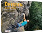
Weitere Infos zum neuen Sportkletterführer für Dresden und Umgebung findet Ihr hier!